Object Record
Images
Metadata
Object Name |
Compass, Surveyor's |
Catalog Number |
2001.009.20 |
Description |
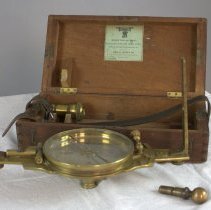
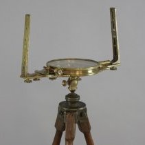
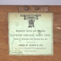
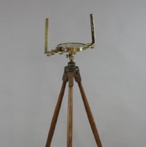
Surveyor's compass in wooden box. Compass made by W. & L.E. Gurley for James W. Queen & Co. All brass, with separate components stored inside box: compass, two sights, plumb bob, 2 swivel pieces, wire. Box has 2 hooks and a lock on the front and a leather handle with buckle attached at the sides. Original paper label inside cover. |
Year Range from |
1860 |
Year Range to |
1893 |
Provenance |
Used by Henry Lueth of La Crosse (1843-1927) He was the La Crosse County surveyor about 1920. Compass probably dates to about 1870. |
Used By |
Henry Lueth |
Made By |
W. & L.E. Gurley |
Material |
Metal/Wood/Leather |
Place of Origin |
Troy, NY |
People |
Lueth, Henry |
Subjects |
Tools "Things that Matter" |
Search Terms |
"Things that Matter" |
Notes |
Featured in Things that Matter Anyone who owns property knows the value of having an accurate record of the boundaries of their land. Whether it is a small city lot or hundreds of acres, the legal description of the property is essential in assuring ownership and avoiding disputes with adjacent property owners. The surveying of land in the U.S. is a result of the Northwest Ordinance of 1787. The ordinance required the government to survey U.S. territory into consistently measured parcels, a system strongly advocated by Thomas Jefferson. As the land surveys progressed, they produced a neatly divided grid across the nation. This grid is still very visible, both in our cities with streets separating blocks that are divided into lots, and in rural areas where large squares of agricultural fields can be seen from the air. La Crosse County was first surveyed by the federal government in the late 1840s. The survey divided the county into Townships six miles square. The Townships were then divided into 36 square Sections. As the land was further divided up and sold, the surveyors' skills continued to be necessary to insure fairness to both buyers and sellers. The surveyors' compass shown here was probably used to create boundaries in La Crosse County during the late nineteenth and early twentieth centuries. The compass, on its original tripod, was used by the local surveyors' office when Henry Lueth was the La Crosse County Surveyor about 1920. The function of the compass was to determine the correct direction of a horizontal property line. Besides the compass, the surveyor also needed to use a 66-foot surveyors' chain and a theodolite, an instrument to measure vertical angles. This compass was quite old when Lueth was the County Surveyor, and was probably considered obsolete. It was made about 1870 by W. & L.E. Gurley, makers of technical instruments in Troy, New York. It sold for about $30.00, with an additional $5.00 for the tripod. Made of brass, the compass includes its wooden case, with room to store its two sights, a plumb bob, a level, and the swivel attachment for the tripod. The box has its original printed paper label inside the lid. The compass was donated to the La Crosse County Historical Society by Lueth's grandson Clinton in 2001. You can see this beautifully engineered instrument with its original case and paper label at the Riverside Museum in Riverside Park. This article was originally published in the La Crosse Tribune. Title: Surveyors' Compass Was Used to Plat the City Author: Robert Mullen Publish Date: April 14, 2018 |